Imaging Systems Provide Maps for U.S. Soldiers
NASA Technology
Spanning nearly four decades, the remarkable Landsat program has continuously provided data about the Earth’s surface, including detailed maps of vegetation, land use, forest extent and health, surface water, population distribution, as well as how these features have changed over time. Managed by NASA and the U.S. Geological Survey, Landsat’s series of satellites obtain data through passive remote sensing, or the use of sensors to read the energy reflected or emitted from the Earth’s surface. After the data from the sensors is processed and analyzed, it can be applied to create information-rich images of the planet.
While the Landsat program has launched seven satellites since 1972, only Landsat 5 and 7 are currently operating. The next spacecraft in line to ensure continuity of data for years to come is the Landsat Data Continuity Mission (LDCM). Planned for launch in 2012, LDCM will take measurements of the Earth in visible, near-infrared, shortwave infrared, and thermal infrared bands. In addition to widespread use for land use planning and monitoring on local to regional scales, support for disaster response and evaluations, as well as water use monitoring, LDCM measurements will directly serve NASA’s research in the areas of climate, the carbon cycle, ecosystems, the water cycle, biogeochemistry, and Earth’s surface and interior.
Partnership
As part of its continuing efforts to develop improved remote sensing technology for monitoring the Earth, NASA’s Goddard Space Flight Center has worked with Flight Landata Inc., based in North Andover, Massachusetts, to refine and test a lightweight spectral imaging instrument for airborne applications. Over the last 10 years, Flight Landata has received numerous Small Business Innovative Research (SBIR) awards to support the technology’s development.
Several advancements for the imaging technology have been made through the SBIRs, including a smaller computer processor for the imaging system, increased sensitivity in the detector system, and a stabilized gimbal system to maintain the unit’s image fidelity despite movement of the aircraft. In 2005, as part of a combined Phase III SBIR with Goddard and the U.S. Army Corps of Engineers’ Army Geospatial Center (AGC), Flight Landata demonstrated the operational capability of a suite of remote sensing instruments in Arizona and California. The demonstration was a success, and afterwards, the company continued to refine the capabilities of the technology.
In 2002, Flight Landata was selected by the Small Business Administration as a winner of the prestigious “Tibbetts Award” in recognition of small businesses and SBIR support organizations exemplifying the types of business, economic, and technical development goals of the SBIR program. By 2006, Flight Landata’s sensor system had incorporated a variety of the refinements and improvements made possible by working with Goddard and the Army, and the system won the Army’s “Greatest Invention of the Year” award.
Benefits
Today, Flight Landata continues to work with NASA through the SBIR program to advance remote sensing technology, but the company also commercially offers the design, integration, and deployment of NASA-enhanced airborne sensor systems, platforms, and collection services. “After developing systems for the government, we were asked if we could deploy, fly, and maintain the systems for the Army. For the last several years, this business has been rapidly growing,” says Petra Botha, Flight Landata’s vice president of finance and administration.
Flight Landata not only supplies the sensor system, it also provides pilots, sensor operators, on-site logistics, and maintenance of the system. The BuckEye EO (electro-optical) instrument suite is flown on the company’s fleet of King Air 100 aircraft to collect extremely high spatial resolution images in three spectral bands. The image data are combined with line scan light detection and ranging (LIDAR) technology to achieve 3D images and to produce digital elevation models quickly.
For the U.S. Army Corps of Engineers’ Army Geospatial Center (AGC), BuckEye addresses a need for unclassified high-resolution geospatial data for tactical missions for intelligence, surveillance, and reconnaissance. The AGC strives to make Buckeye data available to U.S. fighting forces and supporting agencies in a timely fashion. The information can improve the soldiers’ situational awareness by providing highly accurate imagery that can be used to produce current, high-resolution reference graphics and image maps for terrain analysis and operating environment visualization.
As soon as imagery and LIDAR are received at the AGC, they are checked for quality and adjusted to eliminate any distortion due to the camera, lens, or topography. Then the images are combined into large mosaics. The resulting information is available online or through the AGC’s Dissemination Team, including GeoPDF Mapbooks, DVDs, and through high-resolution Urban Tactical Planner databases.
In 2005, BuckEye was deployed to Iraq on a fixed-wing aircraft for an urban mapping mission. In addition to a digital color camera, the LIDAR sensor collected high-resolution, high-accuracy elevation data to provide images of urban landscapes and complex terrain. By 2010, the BuckEye had collected over 85,000 square kilometers of data over urban areas and along main supply routes in Iraq, including over 2,000 tiles of LIDAR elevation data at 1-meter resolution, and 1,800,000 color images at 10- to 15-centimeter resolution.
Between 2006 and 2010, three systems were deployed by Flight Landata to Afghanistan, where a majority of the imagery is quickly processed to provide rapid tactical information. To date, over 40,000 square kilometers of data have been collected. In addition, an Unmanned Aerial System, equipped with a miniaturized LIDAR sensor and BuckEye sensors, is currently operating in western Afghanistan.
According to Petra, one of the reasons the system is so unique is that the imagery it produces is unclassified, so every soldier can see the details of the environment that are critical to planning operations. “It is a unique capability to provide this class of product to soldiers on the front lines,” says Botha. “Had it not been for the NASA technology contracts, BuckEye might not have been deployed to support the war fighter at a critical time in the conflict.”
Now, BuckEye will be used to support the next Landsat Mission. Flight Landata’s airborne system and data reduction technology will be fused with NASA’s thermal infrared sensor technology to provide multispectral images that parallel the ones that will be produced by the sensors onboard LDCM. This data will directly support the calibration of the LDCM instruments. As Peter Shu, an engineer at Goddard who has worked on the remote sensing technology with Flight Landata through the SBIR program, says, “This is a consequence of the SBIR work with Flight Landata. Now we are using it to help in the development of the Landsat program.”
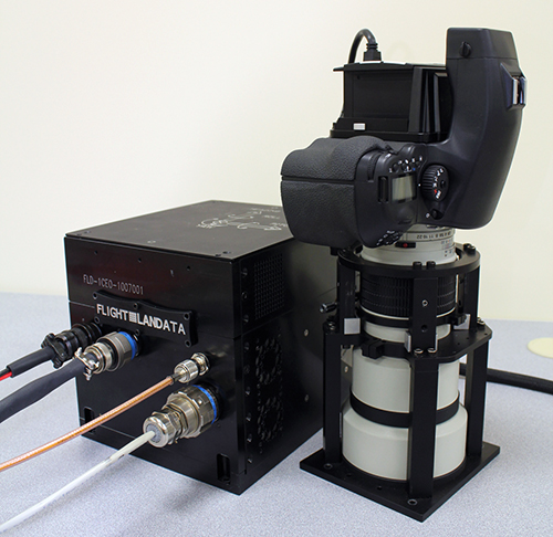
The BuckEye system from Flight Landata Inc. is used for mapping, targeting, damage assessment, and improvised explosive device defeat missions, among others. Over the last 10 years, Flight Landata has received numerous SBIR awards to support the technology’s development.

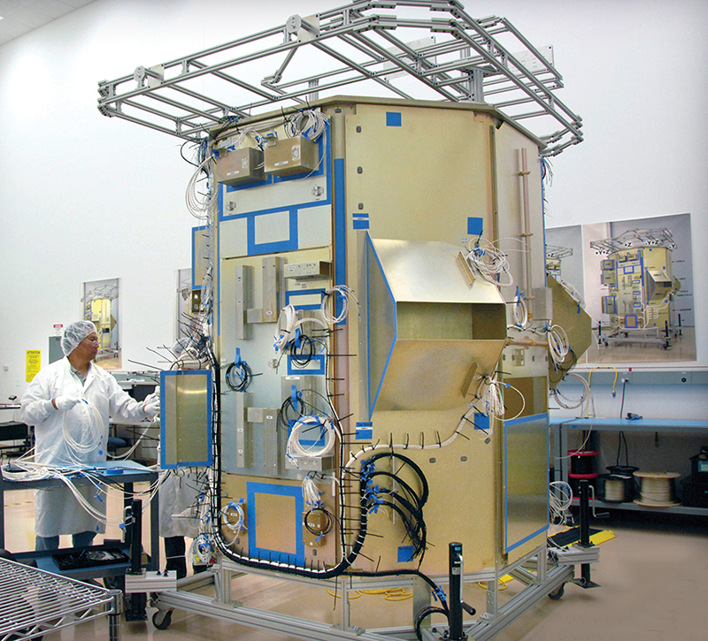
This mock-up of the Landsat Data Continuity Mission is essentially a full scale model of the actual satellite, which is scheduled for launch in 2012. The mock-up enables engineers to check that all components seat and connect correctly. Image courtesy of Orbital Sciences Corporation


